Fall 2017

It seemed that fall was never going to come this year. Atlanta has had record or record-tying high temperatures three times in the last week or so. On Wednesday, Nov 1, there was very little color (other than green) in the trees.

There was fog in Texas Valley. What looks like trees that have lost their leaves for fall are actually trees that died over last winter as a result of the drought in the summer of 2016.

Leah and I were both wondering if there would be any color. At least one fall color prediction map showed our area of Georgia as reaching peak color in late October. We didn’t make it, but by Saturday, Nov 4, there was a hint of color.

On Sunday there was more color on the other side of the mountain.

By Tuesday the maple trees were beginning to show their best color.

Even then there was still a lot of green.

The temperature had dropped on Wednesday and by Thursday it felt a lot more like fall, or possibly even a mild winter day because of the clouds and drizzle. We may miss this wet weather before long. The long-range forecast for the Southeast this winter is warmer and dryer than normal.

And then there was Nate

For the first time I can remember north Georgia was under a tropical storm warning for Sunday. The Channel 5 forecaster was pointing almost directly at us Saturday night.

Hurricane/tropical storm/tropical depression Nate followed the forecast track almost exactly, crossing the top of northwest Georgia during the day on Sunday, but by the time it got here, the watch had been lifted. We got more than an inch of rain from midnight through around noon on Sunday, and then another inch and two thirds during the afternoon, less than the three to five inches predicted, but still enough to satisfy me, and I hope, both the plants and the aquifers for a while.

There was wind. If this fast-moving system is really gone by Monday morning, I’ll see if it brought down any trees when the dogs and I take our walk. The damage will probably be limited to a few branches and lots of leaves in the road.

This late in the year I associate storms and rain with the passage of a cold front, but this was a tropical system, so it brought lots of humidity and warm temperatures. The temperature stayed around 70 degrees all day on Sunday, but it was too humid to open any windows. After this system is gone, we are supposed to have almost summer-like temperatures for the rest of the week.

Irma’s in the was*

Here on Thursday afternoon Hurricane Irma is long gone, not even a tropical depression any more. There were hints of sun Wednesday morning, and even some blue sky on Thursday.

Although in Georgia at least two people died, many areas experienced damage, and more than a million people lost electrical power, we escaped with essentially no problems other than a lot of green leaves blown off the trees.

The last forecasts prior to the passage of Irma into western Alabama called for three to five inches of rain here. Our rain gauge registered about three inches over Monday and Tuesday, although I’m not sure that’s correct. The wind was not extremely strong, but I suspect that it was strong enough to prevent the gauge from measuring correctly. It was the best kind of rain, gentle and long-lasting. There was little runoff anywhere in our yard.

The wind was strong enough to break off a few dead tree branches along Fouche Gap Road, which I tossed into the woods as I walked the dogs Wednesday and Thursday. It was also strong enough to whip a three-trunked hickory tree back and forth pretty well as we looked out from the dinner table. I’m not sure whether they are tall enough to reach the house if one of the trunks fell, but I have to figure that out. Falling trees killed at least one Atlanta man in his house, and an Atlanta woman in her car. As much as I like trees, I don’t want one to fall on our house.

One nice aspect of the storm was the low temperatures. We had highs in the 60’s three days and it was cool enough at night that we debated whether to put a blanket on the bed. Now Irma is gone, the temperatures are predicted to get back up into the mid to upper 80’s in the next week.

*A Language Log post mentioned the expression “in the was” from a BBC interview of a retiring opera singer, referring to her career being in the past. I thought it was a nice expression, so I used it here.

Irma

We learned Thursday night that Hurricane Irma’s expected track will take it almost directly over us, although as a tropical depression rather than a hurricane. This is how we learned about it.

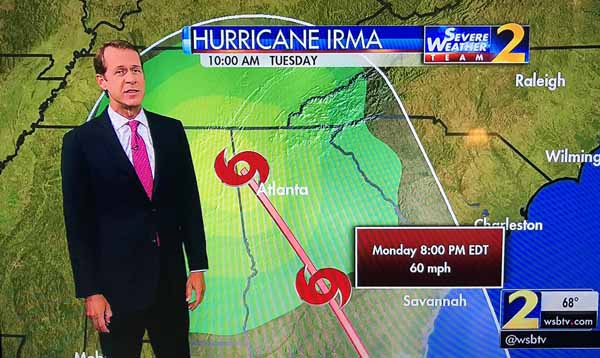
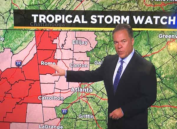
The path goes almost directly over Atlanta and the last point is over us.

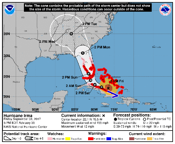
The US National Weather Service shows this as Irma’s expected track as of Friday afternoon.

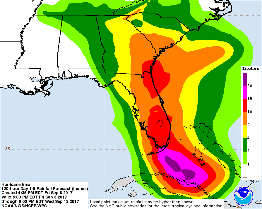
This is the predicted cumulative precipitation amounts. It looks like in Rome we can expect two to four inches of rain.

This is a good example of “be careful what you wish for.” We had been watching the track predictions ever since Irma got far enough along for anyone to predict its path in the US. The early forecasts took it almost directly over Miami and then up the eastern coast almost directly over Savannah, Ga. Atlanta was expected to get some rain from the outer bands, but no effects were predicted for us up in northwest Georgia. Since we are a little short on rain now, I kept hoping the track would move a little west. Now it has.

It’s not that we’re actually in a drought like we were last year, but virtually every time the Atlanta weather people forecast rain for us, we get significantly less than they expect. We have new plants and grass that need water. Our well needs water, too.

Of course, things can change in the next couple of days; the predicted track has already changed significantly. Irma’s path might veer east or west of its current prediction. But we should see fairly soon. Irma is supposed to be in south Georgia by Monday afternoon, and to pass over us by Tuesday afternoon.

The NWS forecast discussion continues to say that Irma is a life-threatening event for the coastal regions of Florida, not to mention the islands it has or will hit.

The NWS discussion of the Irma forecast says, “This afternoon’s NHC forecast was again adjusted a little bit westward following the trend of the ECMWF model and both the HFIP corrected consensus and the FSU Superensemble.” This mild statement says something fairly serious about the commitment of the United States to the NWS and science in general. The ECMWF is the European Centre for Medium-Range Weather Forecasts. Their hurricane model is generally considered the best in terms of its ability to predict the track a hurricane will follow. That is, it’s better than the current US models, which is kind of off, since hurricanes are not much of a problem for Europe, but they most definitely are for the United States. One might naively think that the US would consider hurricane forecasting important enough to commit sufficient funds to get the best model in the world.

But, no, our government thinks that weather forecasting and sciency things like that are a waste of money when there are rich, important people who need tax cuts.

ArsTechnica has an interesting article about the spaghetti plots often shown for Hurricane tracks.

UPDATE Saturday morning: Hurricane Irma’s predicted track has already moved west from last night when I originally wrote this post. It is now expected to cross west out of Georgia into Alabama somewhere south of an east-west line through Atlanta. Atlanta and Rome, as well as Chattanooga, TN, where my brother lives, are no longer in the center of the cone of uncertainty for Irma’s path. We are still, however, in the cone. We are still expected to get somewhere between two and four inches of rain.

Rain watch

I have mentioned before that a fair number of trees in the woods around here died between last summer and this spring. The forest doesn’t look healthy. A lot of trees of all species on the mountain either never came back in the spring or barely made it out of the winter alive. Even the trees that seem less affected by the heat and drought of last summer don’t seem to have leafed out as much as in a normal year, at least to my uneducated eye.

Some trees are trying. A few pines whose needles all turned brown have come back in part. Some of the trees whose limbs never leafed out have sprouted tight bunches of leaves along their trunks. I suspect many of them will never fully recover and will eventually die, especially if we have another summer like 2016.

One of the hardest hit of species is the dogwood. As far as I could tell earlier this spring, we had only one or two dogwoods that seemed to have survived in reasonably good condition. This is one that grew just inside the woods next to our driveway.

Some vines have grown up into the crown, which makes it look like it still has leaves, but the only leaves on this tree are dead. But this is what I noticed at the base of the tree on Wednesday.

It’s coming back from the roots. It looks pretty good at this point.

Here’s a maple that lost about half of its multiple trunks.

And here’s its base.

I don’t know whether the dogwoods or maples will manage to survive, despite these signs of their struggle to live.

This die-off may be a normal cycle in the northwestern Georgia forest, but I worry.

I also worry about our front yard. I finally got the zoysia seed sown. I filled the ruts and depressions as well as I could, then spread about two inches of rich topsoil. Then I raked it as level as I could, which was not very level. Then I rolled it. Every place I stepped ended up with a deep footprint. I could and probably should have tried harder to get the lawn smooth, but I was racing what I thought was a nice downpour that never materialized.

Now all we have to do is make sure the seed doesn’t get too dry. I have watered lightly – very lightly – twice so far. Our well doesn’t produce at a very high rate, so I am being conservative when I water. I am sprinkling about a third of the lawn at a time, then waiting a few hours before doing the next third. Here you can see the middle third is slightly darker than the ground on either side, a result of watering just a short while before I took the picture.

As I write this on Wednesday afternoon, there is a wide area of rain heading from the southwest up towards us. Based on our history here, I won’t be surprised if we get little or nothing from this system.