Distrail

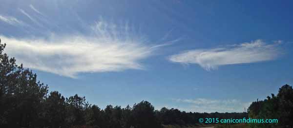
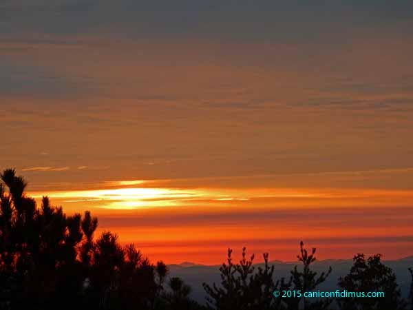
We saw some nice clouds when we took the dogs out for an evening walk Wednesday.

clouds_20apr16

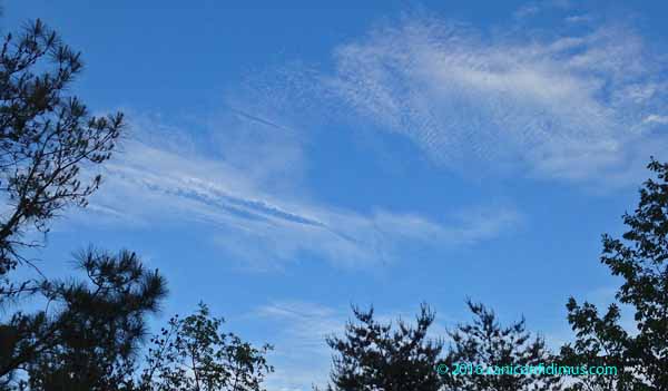
There were some waves and a couple of interesting features associated with the passage of high-altitude airliners. Just to the left of center there are two dark, linear features that are probably, but not certainly, contrails. If that’s what they are, they are probably old (where old means more than a few minutes). They look dark because we’re looking at the under, shaded side. They may not be contrails at all, just linear cloud features.

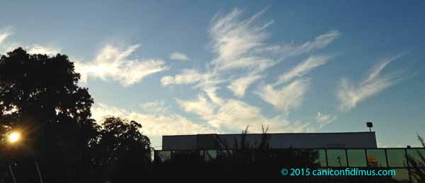
Just above them, however, is what appears to be a negative contrail, a linear feature of apparently clear air within a cloudy region of the sky. This is more likely to be an artifact of the passage of an airliner. A negative contrail is also called a distrail, or dissipation trail. Here’s a little closer look.

distrail

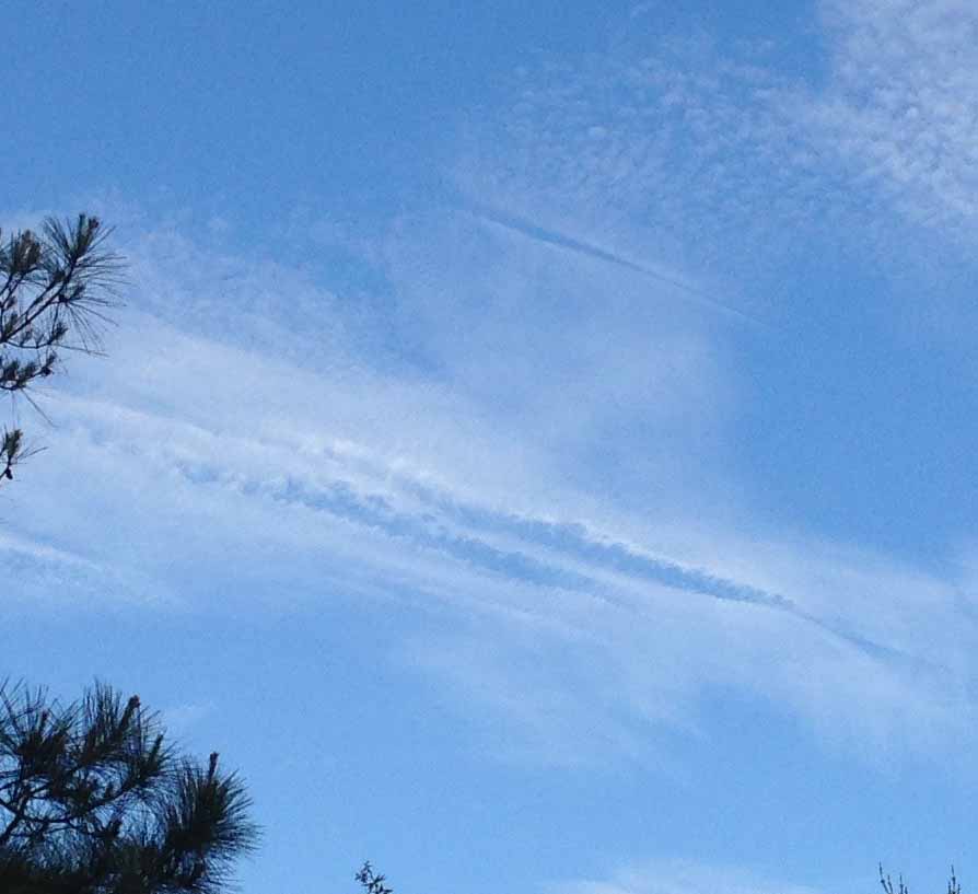
In searching around for an explanation for distrails, I found at least two. One is that the warm exhaust of a jet engine warms the air in the cloud, causing existing cloud droplets or ice crystals to evaporate. A second is that the small particulates in a jet exhaust become condensation nuclei which cause large enough droplets or ice crystals to form that they precipitate out of the cloud, leaving behind a clear region. The website with this particular explanation alternatively attributes the effect to the turbulence created by the aircraft’s passage causing greater condensation and precipitation. Other explanations don’t mention turbulence; I think it’s possible that under the right conditions, turbulence might cause a wake of sorts to appear in a cloud that looks like a negative contrail. I think that’s a different phenomenon from the particulate-condensation nuclei-precipitation explanation.

I think the second explanation (particulates-condensation nuclei-precipitation) is probably closer to right, and the warm air-evaporation explanation is wrong. My reasoning is that the same conditions that cause a condensation trail to form are being blamed for an evaporation trail. The warm (or hot, if you will) exhaust of a jet engine very quickly cools as the gases expand, which causes the water vapor it contains to condense, thus forming a contrail. I can’t think of a way that adding water vapor to air will cause evaporation.

The accuracy of the second explanation is bolstered by accounts of seeing virga or falling ice crystals from the region of the distrail.

third explanation includes some atmospheric optics along with the particulates-condensation nuclei-precipitation process that may or may not be necessary to the explanation of distrails. It relies on optical properties of ice versus water as well as on precipitation. If anyone is interested they can check out the site, which some readers are already familiar with.

On other days in other skies, I have seen what looks like a negative contrail, but these are usually a visual effect. What looks like a negative contrail in those cases is actually the shadow of a higher contrail falling onto a lower cloud deck. It’s sometimes hard to tell the difference because the lower cloud deck can hide the higher contrail, so all you see is a dark trail through the clouds that looks a lot like a view through the cloud to clearer sky.

In this case, I think what Leah and I saw was actually a distrail.

Sky with contrails

contrails

We have lots of commercial jets flying over us, most probably coming to or from Atlanta. Five of them left their contrails for us to see Sunday morning.

Contrails (condensation trails) are caused by water vapor condensing on tiny particulates in the exhaust of aircraft engines. Today we tend to think that means jet engines, but all engines produce at last some particulates. You may have seen photographs of World War II bombers flying at high altitude leaving contrails. Here’s an example taken by the Army Air Corps during WW II.

wwiicontrails

The water vapor that causes contrails can come from the water vapor produced by the engine (burning petroleum fuel produces mainly carbon dioxide and water vapor) or water vapor in the surrounding air. The water vapor may not condense into visible droplets if there are no condensation nuclei. Particulates produced in the engine combustion provide the condensation nuclei that are needed. If the air at the altitude where the aircraft is flying is not very humid, a contrail can dissipate quickly. If it is humid, the contrail can stick around for a long time, or even continue to grow and form much larger clouds.

Our skies must have been fairly humid Sunday morning because these contrails remained visible for some time.

If contrails remain visible for long enough, you may be able to see how the wind at altitude can blow in different directions at different locations by the way the line of the contrail distorts. You could also estimate the wind velocity if you were so inclined.

Bob Roper, a professor at Georgia Tech who was on my reading committee, studied what were called meteor winds. He had a radar unit that looked up at very high altitudes, near the top of the atmosphere. Meteors that routinely crash into the upper atmosphere create ionization trails that reflect radar. By measuring the apparent motion of the ionization trails as seen by the radar, the wind velocity can be estimated. If you’re really interested in meteor wind measurements, you can get one of his articles here for $31.50. Or you could probably visit your local university library and ask for help finding atmospheric science journals. I imagine that neither course will be particularly attractive, and I’m afraid the article would be pretty dry anyway.

As one of the very few scientists doing meteor wind measurements in the West, Dr. Roper sometimes got to visit the USSR, where they also did such work. Back in those days, he would be debriefed by the US authorities when he returned. One time the Russians showed him a radar that could look over the horizon and detect, let’s just say for the sake of argument, ships in the Persian Gulf. He thought that was rather odd, since he was really interested only in radars that looked pretty much straight up. He figured that the Russians would expect him to be debriefed when he returned, and that the Russians probably wanted the US to know the USSR could watch US ships from afar.

Spring comes early …

but it won’t stay.

If you have been watching the news, or if you live in the East and have gone outside, you’re already aware of how warm this December has been. My brother visited us Sunday and pointed out that our daffodils are starting to grow, at the time that most gardeners recommend planting bulbs.

early daffodils

It’s no surprise. Our nightly low temperatures have been higher than the normal highs for days this month.

My brother said that forsythias, which are also spring bloomers, are blooming now in Chattanooga, where he lives. I heard a radio story last week that had reports from a lot of places around the country of blooming plants and even new baby birds.

Unfortunately, the lows here are expected to be below freezing later this week. Neither the early plant growth nor the early birds are likely to survive through the winter, and winter will come, even if it’s late.

I have not seen much about a connection between this warm weather and global warming. Most meteorologists or weather people have talked about a strong El Niño. That usually is associated with wetter weather and cooler than normal winter temperatures here in Georgia. We are getting wet weather, but not cooler temperatures.

Climatologists almost always warn against associating a specific weather event with global warming (or climate change as it has become known, mainly because of conservative opposition to science). However, there are certain mathematical and statistical properties that measurements of many physical quantities follow. Such measurements include things like the height of 20-year-old males or the weight of full-term babies at one year. They also apply to things like measurements of high temperatures on a given day of the year at a given location. Such measurements almost always have what is called a normal distribution. In a normal distribution, measurements tend to group around the average, and have fewer measurements either higher or lower than average. A normal distribution will also have the same number of measurements below and above the average.

Accurate, reliable temperature measurements have been made for a limited time in most locations, so the number of measurements on any given day of the year will be fairly small, probably under 200. As a result, new record lows and highs will be recorded occasionally, although probably decreasing over time as more and more data accumulate. Since temperatures almost certainly follow a normal distribution, there should be a roughly equal number of new record lows and highs over a reasonably long period. If you start seeing more record highs than record lows, it probably means that something is changing. That’s what we have been seeing that in recent years.

Global warming won’t mean that we don’t have cold winters, and it won’t mean that we don’t have new record low temperatures. But it will mean that we will see events like the warm December of 2015 more and more often in the future.

Fall clouds

We have had nearly perfect fall weather for a long time. The temperatures were cool to warm during the days and cool to slightly cold at night. The sky was either deep blue or deep blue with puffy white clouds sailing around. Those days reminded me of an elementary school child’s sky drawing, or maybe the opening credits of The Simpsons.

These are some clouds we say Wednesday afternoon. You can see ice crystals falling out of the cloud on the right (virga).

clouds3_21oct15

These are some thin clouds we saw later that evening. The conditions were favorable for iridescent clouds, but, alas, there were none.

clouds1_21oct15

Looking the other way we could see a train of clouds dropping virga.

clouds2_21oct15

Despite some clouds, the skies were mostly clear and blue for the last couple of weeks. And then Saturday morning it was overcast.

sunrise_24oct15

The forecast was for a good chance of rain Monday through Wednesday. Fortunately, our roof is supposed to be completed by Sunday.

Finally fall

Fall has finally come to north Georgia. We had about an inch and three quarters of rain a few days ago, and then a couple of cloudy days, but Monday morning was clear and cool. It was foggy when I took the dogs for their walk.

suninthefog_2

suninthefog_1

There was a little wind that blew the fog through the trees.

It’s prime time for funnel web spiders.

funnelwebs

There are so many along the road, it’s a little mind-boggling to think about how many of these spiders must inhabit this little patch of forest.

A little further down Fouche Gap Road the sun made another nice shot above the trees.

fogontheroad

It was too bright to get a good shot of the fog, but I did catch something else about 35 or 40 feet above the road, just below the treeline.

webinthefog

I would never have seen it if not for the dew on the web and the angle of the sun.

We walked up to the house on the way back so I could check on a material delivery. Most of the fog was gone.

fog_at_the_house

As we west down on our walk I could see that the valley was pretty much filled with fog. I had been thinking that we were up in the clouds, but we were actually just sticking up above the fog.