And town disappeared

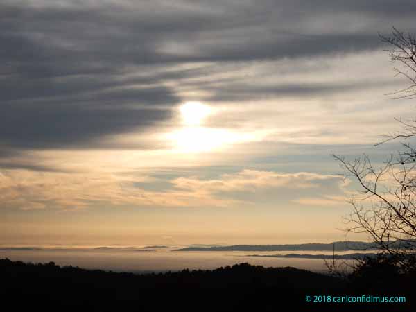
A few days ago Leah got up earlier than me — thanks, Mollie — and saw that most of the rest of the world had disappeared beneath a blanket of fog. She shot a bunch of pictures, and this is one.

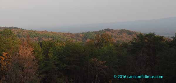
The long ridge on the right is Mount Alto.

We often see spots of fog in the morning, here and there, mainly collecting in the lower parts of the up-and-down terrain below the mountain. This is called valley fog. It’s caused by radiative cooling of the air near the surface which then flows downhill into the valleys, where it collects. If it’s cold enough, water vapor condenses to form fog. So, it’s really a type of radiation fog.

This morning, however, the fog was everywhere, not just in the valleys.

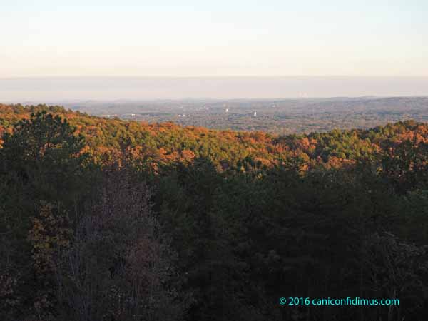
This view is directly towards downtown Rome. The tower is a telephone company antenna.

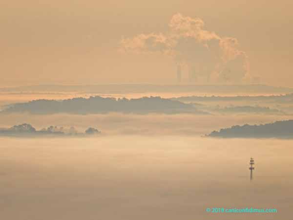
I can’t see the top the City Clock, which stands on what used to be Neely Hill and is now called Clock Tower Hill, but it was just peeking through the fog. The stacks and cooling towers of Georgia Power’s coal-fired generating plant is barely visible on the horizon.

This fog is radiation fog. We had a cool, clear night with conditions just right for fog formation. We also sometimes see a sort of reverse advection fog. Advection fog is usually considered to be the type of fog that forms when warm, moist air moves over a cool surface, causing water vapor to condense and form fog. In our cases, however, it is cool air moving over the warm rivers, causing moisture evaporating from the river to condense as fog in the cool night air. This is usually called steam fog.

We often talk about fog “lifting” as the sun rises. As the sun rises, it tends to warm the ground, which causes the air just above to get warmer and the fog to evaporate. As the air gets warmer, the bottom layer of the fog retreats upwards until all the fog dissipates. If the fog is thick enough, it can keep the surface from warming because not enough sunlight can penetrate. People on the West Coast are probably more familiar with that kind of thick fog that we are here in the Southeast.

This was a welcome change for us. For a couple of weeks we, up here on the mountain, were the ones in the fog. For the people down below, we were up in the clouds.

More sunrises

We aren’t getting up any earlier, but since the sun is rising later, we’re still getting to see some sunrises. This was about 7:13 on Wednesday.

This was three minutes later.

This was at 7:18.

And this was at 7:29.

But wait, there was more sky up there.

There are some nice wave-form clouds up above the lower dark clouds. There are some faint waves oriented differently from most of the other waves, which indicates wind shear in the upper atmosphere. Wind shear can consist of regions of the atmosphere that have varying wind speeds, or that have winds blowing in different directions.

Do you see the dark spots in the lower part of this image? Those are birds.

Stormy weather

The dogs don’t know why there’s no sun up in the sky. Seems like it keeps raining all of the time. Stormy weather.

The dogs agree: stormy weather is bad. Stormy weather, and especially thunder, necessitates seeking refuge, usually in a closet or at the feet of one of the humans.

Mama will keep us safe

This shot was from a few days ago when severe storms came through Georgia, causing at least one tornado. Fortunately the really bad weather missed us.

This shot was from Wednesday when another round of storms hit.

Under the table, between Mama and Daddy’s feet. Safest place around.

The storms on Wednesday were worse than those of a few days ago. We heard a report of another tornado south of us, which was where most of the really bad weather hit. The storms came through in the form of isolated thunderstorms rather than as a uniform wave of bad weather along a front. Here was one pretty severe storm that passed just north of us.

The red pushpin is our house. We got a light sprinkle from this storm, along with some lightning and thunder. The storm that passed south of us was also bad, but it gave us only distant thunder.

I have been working for a few days on channeling the runoff from the yard so that heavy rain won’t wash away what little topsoil remains. This is a partially-finished channel from one downspout of our newly-installed gutters.

It’s a little hard to tell, but there are ripples in the water. It was a fairly strong stream. I will eventually line both sides with stone from around the mountain and put commercial rocks in the actual stream bed. I will probably get some tennis-ball to softball-sized stone from a landscape company to make a bed further down the yard.

This shot doesn’t show the other canyons being dug in other places in the yard. They will get their own treatment soon.

I’m not sure how much rain we got, because our fancy tipping bucket rain gauge seems not to be tipping reliably. I guess I’ll just have to get one of the old-fashioned glass tube rain gauges.

As I write this there are still storm cells tracking towards us and the rest of Georgia, and Sam is under the table at my feet. I keep hearing thunder and Leah sees lightning. We may still get severe weather right here on top of the mountain.

The storm that passed north of us was producing hail around three-quarters of an inch in size. One of the Atlanta TV stations reported that the storm had a BTI of 2.5. Now you may be wondering, as I was, exactly what in the heck a BTI is. So I looked it up. It turns out that it is a commercially-produced index indicating likelihood of tornado production. It means Baron Tornado Index.

As it happens, I know where BTI came from. A Huntsville, Al, TV weatherman named Bob Baron decided to leave TV weather forecasting and form a company to sell weather visualization and analysis software, mainly to TV stations. I remember watching him when I lived in Huntsville. After searching for BTI, I went to the Baron company’s website. I was a little surprised to see how much the company has grown. I looked at their “leadership” listing, and was not surprised to find that everyone they list was basically in sales. They claim to have developed some pretty sophisticated software to forecast hurricane tracks, among other things. That kind of software development and meteorological capability requires a very good development team, but they were nowhere to be seen on the company website. That figures. The ones who do the work get no recognition. The ones who do the selling get all the glory. And, I suspect, most of the money.

They did mention their “chief scientist” in one news release. However, it would have been nice to see at least some mention of the rest of the staff that does all the work behind the glitzy products the company sells, rather than just the salesmen. Maybe they are mentioned somewhere on the company site. They are probably just hidden away so they won’t embarrass the salesmen.

Contrails and a sundog

Saturday morning just after 10 the eastern sky seemed to be full of contrails. There was also a faint parhelion, or sundog.

Shooting into the sun is not a great way to get much detail, but this worked fairly well. The sundog is a little to the left of the sun (about 22°, exactly where it should be). The small, bright blue dot further to the left and down a little is apparently an artifact of the lens of my iPhone.

I haven’t seen quite this many contrails at one time around here. We are close to some flight paths to the Atlanta airport, so airliners often fly overhead. Delta flies almost directly over our house on the Huntsville-Atlanta route; I once actually saw our old house from a Huntsville-Atlanta leg on my way out to California. Contrails usually dissipate before many more planes fly over, but not Saturday morning.

This sundog was a little higher in the sky than one usually sees. They are fairly common if you know when and where to look, usually seen in early morning or late afternoon, fairly close to the horizon. They are usually formed by plate-shaped ice crystals, which tend to orient themselves horizontally as they fall through the atmosphere. The sun’s rays have to pass through them edgewise to form the partial 22° halo, of which the sundog is a part. In order to see them at higher sun elevations, the crystals have to be column-shaped so that they have random orientations as they fall. If the ice crystals are randomly oriented at least some fraction will be at the right orientation to let sunlight pass through them so that a sundog will be visible. And so it was last Saturday.

I love looking out our windows.

Rough Ridge Fire

On Thursday morning we got up and, as usual, I looked out the window to see the sunrise. This is what I saw.

OLYMPUS DIGITAL CAMERA

I wondered why there was a cloud bank with such a clearly-defined edge when there was no passing front at the time. I learned later that it wasn’t clouds, it was smoke coming from the Rough Ridge fire burning in extreme northern Georgia near the Tennessee line. It has been burning since October 16. As of Thursday it had burned more than 10,300 acres. That’s about 16 square miles. The smoke has been blowing down towards the Atlanta area from the Rough Ridge fire and some others.

smokeplume

The smoke was thick enough that a Code Red air quality alert was issued for the Atlanta area. That means that the particulate matter was high enough to be unhealthy for all people.

The wind direction changed on Friday. This is what the view looked like Friday afternoon.

OLYMPUS DIGITAL CAMERA

Downtown Rome, which is usually visible, is almost completely obscured by smoke. There was a noticeable haze up on the mountain and a slight odor of smoke. I think the thickest part of the plume was east of us; it was not bad, but we were clearly within the plume.

The Rough Ridge fire is burning in the Cohutta Wilderness in the Chattahoochee National Forest. It is thought to have started from a lightning strike. At this point it has not reached populated areas, which is good for residents, but its location in the wilderness area has caused problems for fire fighters. The terrain is rough and the area is isolated.

The unusually warm and dry weather and windy conditions have made fire danger particularly high. The relative humidity has been in the 20-percent range, which sounds to me more like what you might see in the western US.

This Web site has some photographs from the fire.

Atlanta’s air quality was upgraded on Friday to Code Orange, which is unhealthy for sensitive groups. It’s better, but still not good. As far as I can tell, our air quality index is Code Yellow, or moderate.

The weather forecast for Friday night was for more windy conditions. One of the firefighters said in an interview that the fire won’t be completely out until we get a long, soaking rain. There is no rain in the forecast for the next week, so we can expect the fire to continue to burn.