When I worked in Huntsville, Al, I occasionally had to fly on business. That almost always meant flying out of the Huntsville airport to Atlanta. I usually tried to get an aisle seat, but on the short flight to Atlanta I liked to sit by a window and stare down at the passing scenery, since we flew over northwest Georgia where we live.
On one such flight I noticed a distinctive mountain formation. There were two ridges that formed an almost completely enclosed valley, and in the middle of the valley there was an oval mountain. I thought that was odd, because it looked so much like the ridges that form Big Texas Valley and Little Texas Valley. I thought that type of formation couldn’t be all that common in northwest Georgia. And then I realized that it actually was our mountains. I looked more carefully and actually saw our house. This image is from Google Earth. When zoomed, out house is very obvious because of the light blue roof.
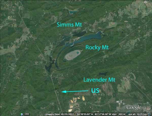
Lavender Mountain, our mountain, forms the southern boundary of Little Texas Valley. Simms Mountain forms the northern boundary of Big Texas Valley. Rocky Mountain sits in the middle, separating the two valleys (which I usually just lump together as Texas Valley). Lavender Mountain has a fishhook extension that turns north towards Simms Mountain and almost closes the gap. A separate mountain extends along the main ridge of Lavender Mountain. That’s Turnip Mountain.
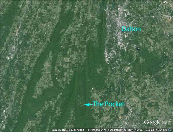
There is another pocket formed by a fishhook mountain near us actually named The Pocket. Here is another Google Earth view.
It turns out that this sort of formation is not uncommon in the Valley and Ridge province of northwest Georgia where we live. This region was formed by folding of strata, with the erosion-resistant sandstone forming ridges and the more-easily-eroded limestone forming the valleys. If you think about an irregularly folded sheet, it’s not hard to imagine how pockets and gaps could form.
Not far from The Pocket there is a little community my father told me about. He said that many years ago when the community was looking for a name for itself, they asked a local doctor to name it, with the provision that he not name it after himself. So Dr. Underwood named it Subligna.
Topo maps often show a lot of towns that don’t exist any more. In the days prior to automobiles and good roads, there were lots of small towns and communities with their own business districts and their own, distinct personalities serving people who didn’t have time for a long trip by wagon to a bigger town. When the automobile became common, most of them disappeared as actual towns. It’s hard to imagine how isolated people were 100 years ago if they didn’t live in a big city, and even Rome didn’t qualify as a big city.
Armuchee, a few miles north of Rome on the way to The Pocket, had its own post office, businesses and a railroad line to connect it with Rome. Maps show a community named Fouche in Big Texas Valley, which had a post office. There was a community named Lavender somewhere on the southern edge of Lavender Mountain that also had a post office and railroad service to connect it with the big city of Rome. Some of Armuchee’s buildings still exist, but today the name just refers to an area with indistinct boundaries miles away from “downtown Armuchee”.
I don’t know whether Lavender ever had its own businesses or even a building for its stop, but as far as I can tell, nothing exists to mark it other than an abandoned railroad right of way.
In searching around for information on our area, I also found the nearby communities of Poetry and Sprite. Like Lavender and Fouche, both of these exist today only as names on topographic maps, or maybe in the memory of someone older than me.
Poetry and Sprite. Those are wonderful names.
Ridger — I thought so, too. I wish I knew the history behind them.
Mark: I opened a WordPress account and accessed CaniConfidimus through WordPress. let’s see if I can post comments this way. Everything else I tried has failed.
This is a test comment from Scott.